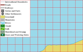
Having completed the new, colour version of the Madasahatta map, I decided that I could make it more user-friendly by splitting it into with sections.
Section 1
Section 2
Section 3
Section 4
Section 5
Section 6
Section 7
Section 8
I hope that fans of Madasahatta (and potential users!) will find these map section useful.


Epic stuff
ReplyDeleteGeordie an Exiled FoG,
DeleteCheers!
All the best,
Bob
Great idea to have seperate sections, so you can zoom in as required.
ReplyDeleteSteve J.,
DeleteThat’s exactly how I hoped that people would use the map sections!
All the best,
Bob
They will work well Bob. The small sections are easy to copy and print. Thanks for giving the map a new lease of life. Cheers Greg
ReplyDeleteDelta Coy (Greg),
DeleteI am thinking of making the map sections available in PDF and/or BMP format so that potential users can adapt them to suit their particular requirements.
All the best,
Bob
Thanks Bob. Very useful for a potential Campaign.
ReplyDeleteMaudlin Jack Tar,
DeleteCheers!
David Crook and I are looking at adding some detail to the Dodgilot area ... possible with some mountains (inhabited by Afghan-like tribesmen), a French enclave, a small Boer republic, and the Dodgilot ... who are related to the Zulus!
All the best,
Bob
I just purchased a copy of the Madasahatta campaign book. One of my boys sat with me and we had a few good laughs at the puns but I have a question. The newsletters were clearly typed, cut and pasted like we used to do before desktop publishing became a thing but how was the map shown in the book created? I swear it looks like it was done on a Macintosh or similarly early computer. Any recollection of how it was put together?
ReplyDeleteMr. Pavone,
DeleteI’m pleased that you and your son have enjoyed the Madasahatta book.
The very first map (now lost) was hand drawn but by the time we began the campaign proper, it had been drawn (not by me) on a very early computer. I think that you might be right about it being a Mackintosh … but I’m not absolutely sure.
All the best,
Bob